Origin
Officially established in January 2016 through Memorandum Circular No. 2, s.20161 to collect core datasets and support the information exchange platform as ways to obtain a common operational picture during crisis.
Purpose
Serve as the venue for NDRRMC Member Agencies and key partners involved in DRRM to address disaster-related data and information availability, quality and accessibility, as well as system interoperability issues across the emergency cycle.
Vision
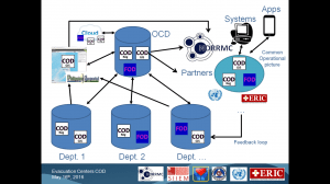
- Mandated departments develop and maintain the Common and Fundamental Operational Datasets (CODs/FODs) based on IM-TWG’s specifications;
- The Office of Civil Defense (OCD) can access the CODs/FODs either directly through APIs or indirectly through platforms such as the Philippines Geoportal;
- OCD server contains the all dataset which is regularly and automatically updated through the APIs and a copy is placed on the cloud to allow for the OCD to be operational from any place in the country;
- All IM-TWG Members have access to the database in question for all stakeholder involved in DRRM to have a common operational picture;
- Information systems and Apps complying with IM-TWG’s interoperability specifications use the database for their respective operations and help filling potential data/information gaps;
- A feedback loop mechanism allows for the additional or updated data/information collected to be integrated into the official COD/FOD after validation.
- Expected outcomes:
- All the necessary geospatial (COD) and statistical (FOD) data needed to take decision will be available, of quality and accessible to all NDRRMC Member Agencies and key partners during the different phases of the emergency cycle (prevention, mitigation, preparedness, response, rehabilitation and reconstruction). This common dataset will not only provide a common operational picture to the all DRRM community but also allow for the generation of cluster specific products (maps, tables and graphs);
- All the DRRM based information systems in the country will be interoperable and their content compatible;
- The data and information management capacity of governmental agencies will be strengthened.
Governance
- Co-chaired by the Office of Civil Defense (OCD) and the Department of Social Welfare and Development);
- Secretariat provided by OCD and ERIC.
Membership:
- NDRRMC Member Agencies;
- Other governmental agencies mandated to collect, manage and share the identified CODs and FODs;
- Key partners and stakeholders invited by the IM-TWG Chair.
- Currently counting 434 Member representing the 44 NDRRMC Member agencies as well as 64 other governmental agencies, departments and other institutions from international and local NGOs, the academic and private sector;
Major achievements so far:
- Monthly meetings aiming at building the community, sharing knowledge and working on commonly identified issues;
- Development of Geospatial and tabular data specifications and standards;
- Identification of the priority Common and Fundamental Operational Datasets (CODs/FODs) to be developed and maintained;
- Launching of the CAFOD project aiming at operationalizing the identified priority CODs.
- Country example for the development of the UN-GGIM Strategic Framework on geospatial information and services.
Way forward
- Operationalizing the priority CODs, starting with Barangays and Evacuation Centers;
- Defining the IM-TWG Implementing Rules and Regulations (IRR);
- Strengthening and homogenizing data management capacity and practices among IM-TWG Members.
For more information:
IM-TWG web site: http://digitaleducation.net/im-twg/
IM-TWG Secretariat: twg2016@gmail.com
